
This outlier of Donegal’s Bluestack range had vaguely been on my radar for years. I finally climbed it at the weekend as part of an annual pre-Christmas hike and get together with some of my hiking buddies.
Aghla’s rugged bulk rises from the southern shore of the 5km-long Lough Finn, source of the River Finn, near Fintown village (why wasn’t the latter anglicised with two ‘t’s as well?). It shouldn’t be confused with the slightly lower Aghla More and Aghla Beg further north, near Errigal.
The original plan was to walk the circular (well, more triangular) route described in Adrian Hendroff’s ‘Donegal, Sligo & Leitrim A Walking Guide’. Due to missing an early turn-off, however, we ended up doing a broadly similar circuit but in reverse.
As the book recommends, we parked at the western end of the lough at the Pairc Acla Gaelic grounds. From here we followed a track past some houses into the forest which stretches along part of the mountain’s northern slopes.

Looking back on Lough Finn’s western edge from the farm track

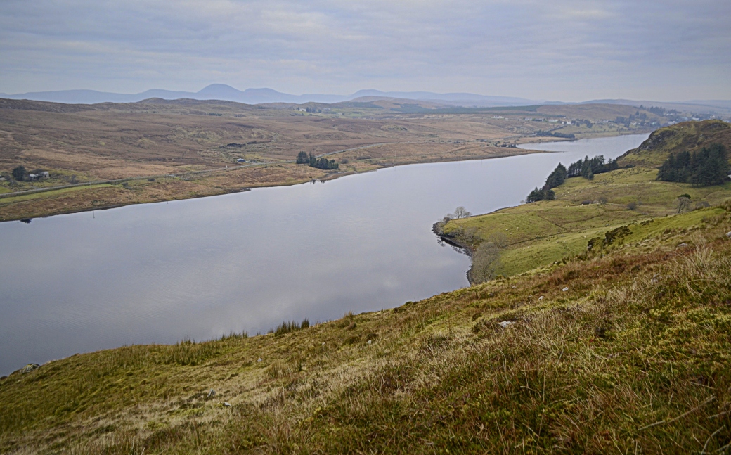
View of the lough from the forest
We emerged at the far end of the forest and immediately headed uphill. The terrain was steep and tiring after the gentle, undulating early part of the walk but we stopped a few times to take in the ever-widening views: over the lough and the Derryveagh Mountains which soon appeared beyond, and even out to the Atlantic around The Rosses area.
After climbing above the forest, we headed in a southerly direction towards the summit, initially following a fence line over heathery terrain.

Sharron taking in the views behind us: the conical profile of Errigal can now be seen to the left of Slieve Snaght
After reaching a more open, rocky area we veered to our left, away from the fence. From here it was a long, zig-zagged route over a number of false summits as we wondered would we ever see the top of Aghla on this short December day. Eventually, we reached the first of a number of small, often unnamed loughs dotted around the mountain’s upper reaches.

A tiny lough with no name
From here we headed for obviously higher ground to the southeast and passed the larger Castle Lough as we made our way towards the summit, via another fence crossing. Finally the trig pillar came into view, perched on a rocky height. It was all the more welcome because for a while we thought we might be leaving without seeing it; always a disheartening prospect for a summit bagger.
We spent some time at the trig taking in the views before enjoying a lunch break just below it. While not sunny, visibility was reasonably good and we could see a large swathe of Donegal: mountains, peninsulas and islands laid out before us.

My hiking buddies having lunch below the trig pillar

A view to the south from the summit
For me personally it was a slightly frustrating experience, however. Usually in Ireland (certainly the northern part), I have a fairly clear idea of what I’m looking at from a mountain top. But from here most of what I could see was new and unfamiliar. It did make me want to come back to the Bluestacks proper, to help fill in the blanks (the only other one I’ve been up is Croaghconnellagh, overlooking Barnesmore Gap).

Summit view over more mountain loughs towards the coast at The Rosses (yes, I had to check Google Maps)
Suitably replenished, and looking forward to a night out in Donegal Town, we began our descent. Our initial plan was to reverse the book’s route for ascending the mountain, by aiming for the western edge of Lough Finn. Instead, we ended up veering more to the right (east) to avoid the steepest ground.
It was still a slow and meandering path over difficult and often wet terrain, with a bit of deliberate backside-sliding. As with the ascent, though, we got some fantastic views: over the entirety of the lough at one point and down over Pairc Acla.

Eventually finding ourselves close to the forest edge, we decided to enter it in the hope that the terrain would be less difficult. Progress was still slow, navigating around and under dead trees, but at least the ground was dry. We emerged onto the hillside further down then back onto the farm track.

Lovely little donkey back near our start point
Total distance: 7.4km / 4.6 miles (the book route is almost the same at 7.5km)
Map: OSI 11
If you enjoyed this post, please feel free to leave a comment or share via social media (buttons below).

Thanks Martin, I enjoyed reading this and perhaps one day I will get there. Only 2 more weeks to Christmas so Happy Christmas to you and yours.
LikeLiked by 1 person
Thanks Ashley, it was a great walk but tricky enough, especially coming down. Hope you have a lovely Christmas too.
LikeLiked by 1 person
Great stuff Martin. Certainly rings a bell with me with the steep climbs and false summits. Brilliant mountain though, and well captured in your photos.
LikeLiked by 1 person
Cheers Aidy, yes it was definitely tougher than I expected, one of those walks you enjoy more in hindsight! Great mountain though and I enjoyed the views, especially over Lough Finn.
LikeLike
Looks like a very nice mountain, you were fortunate to get such clear views. Most unlike you though to not recognise exactly every feature in view. Nice blog, must do this one sometime.
LikeLiked by 1 person
Thanks Canice, yeah it killed me 🙁 We should do more of the Bluestacks.
LikeLike
Yeah I live so close, yet have done very few of them. New Years resolution?
LikeLiked by 1 person
Yeah that and the other ones you said you’d do. But yes, it’d be nice to gradually work across them.
LikeLike
Hi, just discovered your blog via your mention in MV, interesting report and nice pics given the dull weather. I had a similar experience when I climbed this beautiful mountain with a friend about three years ago, and would like to climb it again, as I really enjoyed the summit area -which we had no time to explore, unfortunately- and the views !!
LikeLiked by 1 person
Hi David, thanks for dropping by! It’s a great mountain and one I’d go back to too, ideally on a sunny day. It’s a little isolated which gives it a unique view over much of Donegal. A tougher challenge than you’d expect too, for its height.
LikeLike